Meeting everyone at Badger's cove at the end of Five Mile Bay to snowmobile through the lakes. Taken Feb.26/16
Picking up another member at Wood's Bay. Taken Feb.26/16
Lunch at H&H Restaurant on Kapacog Lake near Mactier. Taken Feb.26/16
Friday, 26 February 2016
Wednesday, 24 February 2016
The satellite view of Lake Huron and Georgian Bay taken Feb.23/16
http://coastwatch.glerl.noaa.gov/modis/modis.php?region=h&page=1
http://coastwatch.glerl.noaa.gov/modis/modis.php?region=h&page=1
Monday, 22 February 2016
Sunday, 21 February 2016
All the snow on the ice on Kineras Bay turned into 2" of slush. The slush now has a thin layer of ice on top. I expect this to freeze solid tonight with the predicted -18c temperature. Taken Feb.21/16
This shows the south entrance to the snowmobile trail into Kineras Bay.
I took these pictures along the snowmobile trail into Kineras Bay. Taken Feb.21/16
This shows the south entrance to the snowmobile trail into Kineras Bay.
I took these pictures along the snowmobile trail into Kineras Bay. Taken Feb.21/16
Saturday, 20 February 2016
Thursday, 18 February 2016
Monday, 15 February 2016
I made it into town by snowmobile today for the first time this season. This is Five Mile Bay looking toward Dunroe Is. The ice in the center ranges from 5 to 6". There are patches of slush 2 to 3" thick. The ice near the shore is 6 to 8" thick and the slush has mostly frozen. Taken Feb.15/16
Renee and Jim Hoculik's place on Victoria Island. Taken Feb.15/16
George and Danna Bowersox's place on Malaren Is. Taken Feb.15/16
Renee and Jim Hoculik's place on Victoria Island. Taken Feb.15/16
George and Danna Bowersox's place on Malaren Is. Taken Feb.15/16
Clarke's place on Louisa Island. Taken Feb.15/16
I found 7" of ice between Shasha and Beauty Island. taken Feb.15/16
On the south side of Gash Island ( Bowens) there is 4" of ice close to shore. This was open water a few days ago. Taken Feb.15/16
The west entrance to the Indian Dock Channel has 4" of ice. I take the trail to the left thorough the bush to bypass this area. Taken Feb.15/16
Sunday, 14 February 2016
Friday, 12 February 2016
Steve Sprague's cottage on Five Mile Bay at the entrance to the Indian Dock. Taken Feb.12/16
8" of snow fell last night and today. There is now 12" of snow on the ice and it is starting to get slushy. The weight of the snow sinks the ice allowing the water to come up turning the snow to slush. Over the next week this will freeze solid making thicker ice. Taken Feb.12/16
8" of snow fell last night and today. There is now 12" of snow on the ice and it is starting to get slushy. The weight of the snow sinks the ice allowing the water to come up turning the snow to slush. Over the next week this will freeze solid making thicker ice. Taken Feb.12/16
Thursday, 11 February 2016
Wednesday, 10 February 2016
Saturday, 6 February 2016
Thursday, 4 February 2016
Approaching the swing bridge on the way home from town. Taken Feb.4/16
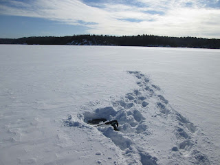
Glen Burney is on the left and the north end of Isabel Is. is on the right. I drilled the ice on the snowmobile trail to the Menominee and found 3" of ice. Taken Feb.4/16
Approaching the Two Mile Narrows.
Two shots of five Mile Bay. I found 4" of ice in the middle. Taken Feb.4/16
On Seven Mile Bay approaching the Seven Mile Marrows.
Kineras bay straight ahead. Taken Feb.4/16
Subscribe to:
Comments (Atom)


