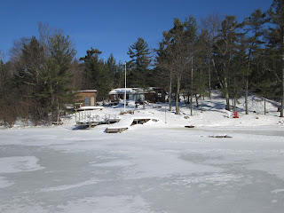
I got about half way into town but found only 4" of ice here on Five Mile Bay. I require 6" of ice to proceed. Taken Jan.30/17
Monday 30 January 2017
Thursday 26 January 2017
This shows Camp Tapiwingo from the channel. It is open water all the way to shore. Taken Jan.26/17
This shows thin ice off the end of Isabel Is. across from Glen Burney. This ice is less than 2" thick with a large area of open water just past the point. Taken Jan.26/17
This show thin ice (less the 2") all the way to Glen Burney Marina. Taken Jan.26/17
This shows thin ice off the end of Isabel Is. across from Glen Burney. This ice is less than 2" thick with a large area of open water just past the point. Taken Jan.26/17
This show thin ice (less the 2") all the way to Glen Burney Marina. Taken Jan.26/17
The western end of Mainchip Is. Taken Jan26/17
This shows the mainland point at the eastern end of Mainchip Is. I found 5" of ice here. Taken Jan.26/17
I found 5" of ice here on Five Mile Bay in front of Dunroe Is. Taken Jan.26/17
I found 6" of ice here out from the entrance to the Menominee Channel on Five Mile Bay. It seem the mild spell the past five days reduced the ice by about 1". Taken Jan.26/17
Friday 20 January 2017
The east end of Mainchip Is.
I found 6" of ice here on Five Mile Bay in front of Dunroe Is. Taken Jan.20.17
I found 7" of ice on the snowmobile trail on Five Mile Bay just out from the entrance of the Menominee Chanel. Taken Jan.20/17
This shows the snowmobile trail from Glen Burney into the mouth of the menominee with Isabel Is. center left. This dark area which was open water last week is ice about 1 1/2 thick. Taken Jan.20/17
This is the range just west of Slope Is. in Parry Sound Harbour. I found 6" of ice here. The ice is very poor in front of Point Pleasant and over toward the swing bridge. There are large areas of open water towards the mouth of the Sequin River and Bob's Point. Taken Jan.20/17
Here are some picture from my weekly trip into town. I was hoping for some sun shine but at least it didn't rain. The mild weather and rain forecast for this weekend will reduce the ice coverage until the weather cools next week. Taken Jan.20/17
Sunday 15 January 2017
This shows the center of the channel between Redner Bay and Amanda Is. I found 6" of ice here. Taken Jan.15/17
I made it as far as this small island about just off McLaren Is. about 2 miles from the first narrows of the Indian Dock Channel. I found 4" of ice here. Taken Jan.15/17
The eastern narrows of the Indian Dock Channel.
A few pictures of Redner Bay. Taken Jan.15/17
I made it as far as this small island about just off McLaren Is. about 2 miles from the first narrows of the Indian Dock Channel. I found 4" of ice here. Taken Jan.15/17
The eastern narrows of the Indian Dock Channel.
A few pictures of Redner Bay. Taken Jan.15/17
Thursday 12 January 2017
Entering the Seven Mile Narrows from Kineras Bay.
Craganmor Pt. Resort.
Looking east into Seven Mile Bay From the cut.
Seven Mile Bay. The ice is about 2" thick.
The view of Five Mile Bay near Dunroe Is. The ice here is about 2" thick.
The snowmobile trail from Glen Burney to the Menominee Channel.
Approaching Point Pleasant Marina.
Taken Jan.12/17
Sunday 8 January 2017
Here is a satellite photo taken Jan.8/17 showing lake Huron and Georgian Bay. You can see that Five mile Bay and Parry Sound Harbour are frozen over. It shows the Sound open with ice between Kilbear Park and Parry Island. The Muskoka Lakes are also frozen except for two small areas.
Here is the link. They post 2 or 3 photo a day.
https://coastwatch.glerl.noaa.gov/modis/modis.php?region=h&page=1&template=sub&image=t1.17008.1656.LakeHuron.143.250m.jpg
Here is the link. They post 2 or 3 photo a day.
https://coastwatch.glerl.noaa.gov/modis/modis.php?region=h&page=1&template=sub&image=t1.17008.1656.LakeHuron.143.250m.jpg
This picture was taken from the bay looking toward the back of Freedom Is. The ice here consists of 1" of ice with 4" of slush with 1" of ice below. Not something I feel safe walking on at this time.
The channel in front of Craganmor is now frozen.
I tried to scoot into Parry Sound last Friday but had to return after making it to the end of Seven Mile Narrows. Seven Mile Bay was frozen over. There was thin ice with four to six inches of slush covered with about two inches of snow. It is easy for the scoot to get stuck in. This picture shows the scoot stuck in the middle of Kineras Bay in front of my place. Pictures taken Jan.8/17
Subscribe to:
Posts (Atom)


